I am having the best holiday of my life. Yesterday we arrived in Iceland and toured around the Reykjanes peninsula and what a great start of the holiday. If you have not read part 1 yet… click here.
Day 2 of 14: from Grindavik to Borgarnes
We cross the border from Reykjanes into the capital area. We have no intention to stop at Reykjavik, since we will end our holiday in the capital city. The plan today is to go to West Iceland. And our first stop on our program is Old Akranes Lighthouse. We have about 1,5 hours to go. We stop in Vellir to get ourselves some bread at the local supermarket and we continue our journey straight after. The weather has changed and it has started to rain and the wind blows strong as. We are comfortable in our little 4WD though and spend most of the drive on the highway, passing Reykjavik and going through the Hvalfjörður/Hvalfjördur Tunnel to reach Akranes.
I wonder if we should have gone to Glymur waterfall instead. We skipped that on our program, because it takes quite a bit of time to reach this waterfall. When we reach the lighthouse, it is pooring outside. Together with the wind it makes going outside not very inviting. We decide to wait for a while and make ourselves a noodle soup in the car. But since I love lighthouses, I do not regret coming here. There are 2 lighthouses and the big one is open to public. Well normally, because today it is closed. Maybe because of the weather. We quickly go outside to have a look, see empty fish racks, take some photographs of the lighthouses and have a toilet stop before we move on. The area around the lighthouse is not very inviting today, but I am sure it looks a lot better when the sun is shining.


We continue our journey towards Hraunfossar, which takes us about 1,5 hours. The landscape changes all the time and so does the weather. Rain, clouds, a tiny bit of sun, rain, clouds, etc. I love it though! Iceland is a country of extremes and that goes for the weather as well; it either suits you or it does not! When we arrive at Hraunfossar it is still raining and it is a bit windy. We put on our rain gear, so we are fine. I decide to take my camera with me instead of just carrying my phone. But it is impossible in this kind of weather. So, I go back to taking photographs with my phone (which fortunately has a pretty good camera).
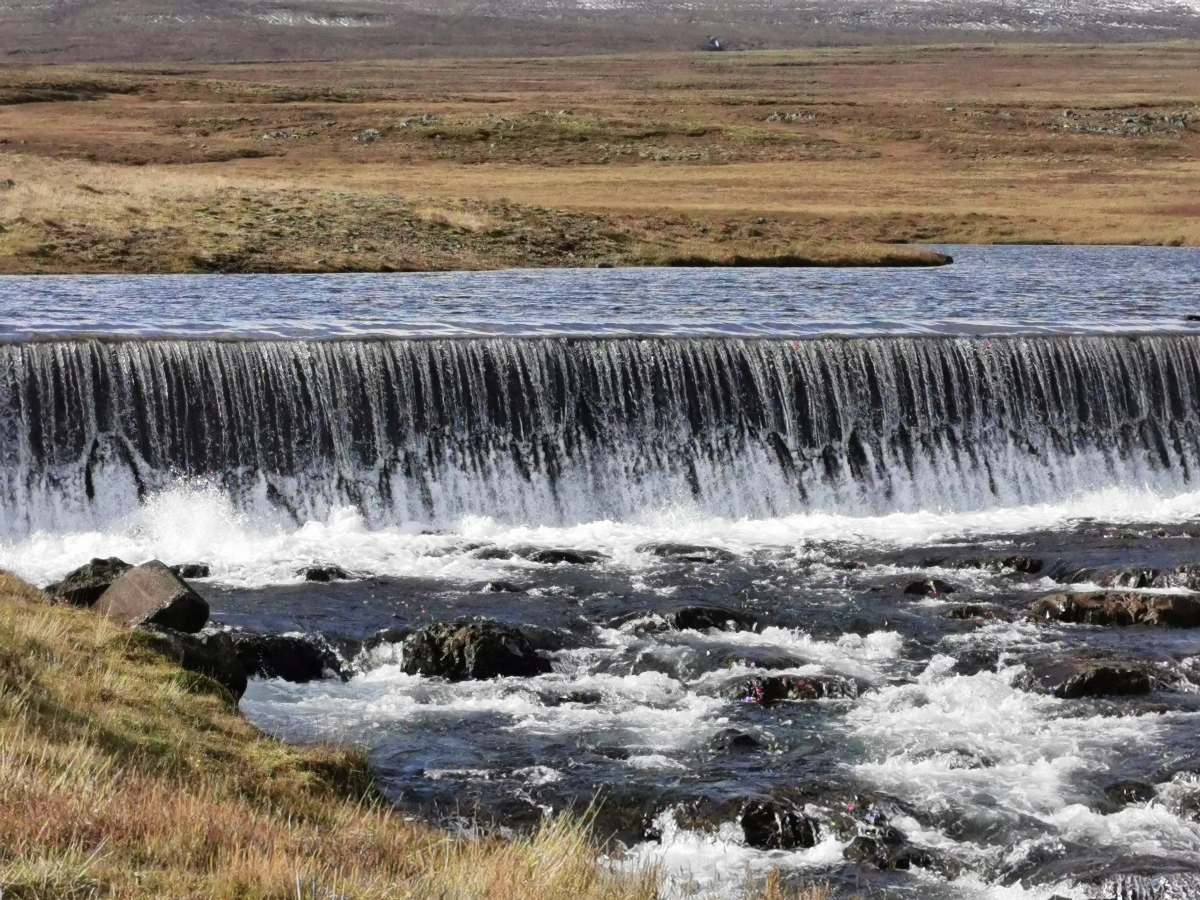
We stop at the viewing platform near the car park. Hraunfossar is actually a series of waterfalls and they stream over a width of almost 1 kilometer out of the Hallmundarhraun, which is a lava field. The name comes from the Icelandic word for lava which is hraun and the word for waterfalls if fossar (a little lesson in Icelandic 😉 ). The waterfalls pour into the Hvitá river which normally has a bright blue colour. Not today though with the lack of sun. But the waterfalls are truly impressive and the trees above it with their automn colours make the scenery so beautiful. I simply cannot stop looking at the way the water flows. Nothing beats mother nature!


A little bit further from Hraunfossar, there is another waterfall called Barnafoss (meaning waterfall of the children). I am not sure I want to know why this waterfall is named Barnafoss; it turns out to be a sad story and the story claims that 2 children from a nearby farm fell to their deaths crossing the river on the natural bridge. The waterfall is a force of power and the water goes through the canyon wildly. We walk back and cross the man-made bridge between Barnafoss and Hraunfossar to the other side of the water, just to see what the view from there is like. The scenery remains stunning. We walk back, have another stop at the viewing platform and walk to our car. There is a restaurant and souvenir shop close by the parking and they are open all year round.

Before we go back towards the coast, we want to visit Deildartunguhver. When leaving we go east. Google Maps is confusing us, because it gives 2 locations of Deildartunguhver on the map. We actually passed the geothermal area on our way up to Hraunfossar, but we did not realize it with the rain coming down quite heavily at the time. We drive by Husafell Hotel (National Geographic Lodges has it on their program) and I ask Astrid to turn so I can have a look. One of my clients (who is also a dear friend) told me about this hotel just before I left and how weird is it that by accident, we drive by it. It is an amazing place to stay, it looks absolutely stunning and the location is just the best. Hopefully a next time (I am only here for 2 days and already think about going back to Iceland ;-). If we go a bit further, we will find Víðgelmir lava cave. It is late in the afternoon though and the tours will not go anymore.


We turn back and find Deildartunguhver and park our car. I just love these geothermal areas. They have something weird and mysterious about them and make you realize that our planet earth is just a true wonder. Deildartunguhver is a hot spring, the water emerges at 97 °C and it is the highest-flow hot spring in Europe. We around surrounded by steam since the wind is strong and blows it into all directions, but that makes the place even more mysterious. It is busy at the parking, not just because people want to see the hot spring. They come to visit Krauma natural geothermal baths & spa at Deildartunguhver. They mix the hot spring water with cold water from Rauðsgil, which originates in the glacier Ok. The baths look pretty inviting, but we want to make our way back (when it is still light) to Borgarnes, where we will spend the night.

The drive to Borgarnes is only half an hour; we take road 50 instead of the ring road. That way we enter Borgarnes via the Hvítá bridge. After having crossed the bridge we stop at the gas station and fuel up the car. The tank is not empty yet, but fuel up when you can during your Icelandic holiday. And doing it now it will save us time tomorrow morning. We drive to the centre and check into Hotel Borgarnes, just before 2 busses of Asian tourist come in (lucky us). The location of the hotel is perfect and our room spacious and the beds comfortable. From here we will not need a car to discover Borgarnes. We are not even in our room for 5 minutes when we look outside, see the sun coming out beneath the clouds, creating the most beautiful rainbow.

We put our coats back on and go outside. The rainbow is there to stay, so we have plenty of time to take photographs. The view over Borgarfjörður/Borgarfjördur is stunning! The weather is peaceful now; there is hardly any wind, we see smooth waters and a beautiful sky. It is getting colder though, but I prefer it cold and sunny. We walk around town as the sun starts to set. I love sunsets and take about 100 photographs every time there is one.


Astrid is a bit hungry so we find ourselves a place to eat. In the old part of Borgarnes town lies a beautiful cove, called “Englendingavík” which means “The Englishman Cove”. This part of town is something else. Old buildings, beautiful scenery and the sound of the sea! We go inside the coastal style restaurant by the same name. Inside there is a relaxed atmosphere. We order salmon with potatoes and drink a Boli. It feels like we have been in Iceland for a long time, but it is only our second day! The meal is simply delicious and we take our time to enjoy it. I can highly recommend this restaurant. Close to closing time we pay our bill and walk back to the hotel. The temperature is close to freezing point and once we are back in our room, we have a warm shower before going to sleep. The rainbow, the walk around Borgarnes, the sunset and the dinner… it was all just a perfect ending to another impressive day!

Day 3 of 14: from Borgarnes to Stykkishólmur
We get up early, have breakfast and check out of hotel Borgarnes. Today we will drive around the Snæfellsnes/Snaefellsnes peninsula and we want to have as much time as possible since there are a 1000 things to do and see! When we get in the car, we see another rainbow. As we leave, we drive past the restaurant where we ate last night to capture it. We have a quick stop at Borgarneskirkja and we see the clouds closing in on us. It creates another pretty picture. Time to make a move…

We make our way up north on the 54, the sky is decorated by rainbows; what a pretty sight! The sun slowly disappears though. We enter Snæfellsnes after about half an hour and our first stop is at the Gerðuberg/Gerduberg Cliffs. You can hardly see Gerðuberg from the road, although the cliffs are not far from the road and they are half a kilometre long. We drive passed the cliffs since a bit further we see a little church, Ytri-Rauðamelskirkja. We park our car and walk towards it. I can look inside through the windows; it looks like the church has been closed for quite some time. Dead flies lie everywhere; a shame because the church looks real pretty on the inside. Behind the church there is a crater. The autumn colours of the heather cover the walls of the crater; beautiful. We drive back to Gerðuberg/Gerduberg Cliffs and all of a sudden, the rain comes pouring down. We wait for a while in the car, because we want to go outside. The location is perfect for having a look at (hundreds of) basalt columns, neatly stacked next to each other… side by side. We watch from a distance and decide to move on… 😉


Driving around the peninsula is pure pleasure; I guess no matter what the weather conditions are like. Today it feels like the weather changes every 5 minutes. After 45 minutes we stop at Bjarnafoss and all of a sudden hail comes down from the sky. But as quickly as it came, it stops. We go outside, this is our first waterfall where we stop and believe me… it is not the last ;). But of course, we are impressed. It falls down from basalt cliffs and if you have a good eye, you can see the basalt columns. It looks like the sun is coming out again, so we go for a walk. I love waterfalls, the force of the water, the way it decides to flow… The top of Volcano Mælifell/Maelifell who lies “next” to the waterfall, is covered by snow. Last night the tops were covered in clouds and this morning we could feel the cold wind coming from the fresh snow on top of the mountains/craters. It is all so beautiful and impressive; just WOW.


The sun starts to shine bright, so we quickly make our way to Búðakirkja/Budakirkja which lies “opposite” from Bjarnafoss; 3,5 km’s south. Búðir itself is a small hamlet located in the lava fields of Búðahraun/Budahraun. Búðir/Budir consists of a church and a country hotel and that is it. The famous black church is probably the most photogenetic and photographed one in Iceland. And I can understand why; because both the church and its decor are absolutely stunning. There are lots of people when we get there, trying to make the best photograph possible. So, it takes a while before I can make my “perfect” pic (meaning without having humans in it). I also go close and put my camera against the windows, so I can see its interior. The churches interiors are simple in Iceland, but that is where the beauty lies and that goes for almost everything in Iceland.


It is not so difficult to decide where to go or to stop next. When driving around the peninsula you just go where you see a lot of people/cars and know that there is something special to see. Although I am sure there are hidden gems everywhere and people do not know about it. It is actually still busy this time of year, but not too busy though. We leave road 54, continue on Útnesvegur. We stop after about 10 minutes to take photographs of the spectacular scenery and I see a group of kids riding horses. I would love to go horse riding; it has been a while though. But I do not think it is Astrid’s cup of tea and our program looks already full enough as it is.

Only 5 minutes further we stop at Rauðfeldsgjá/Raudfeldsgja Gorge, located at the east side of Botnsfjall mountain. Well, we need to walk about 20 minutes uphill before we really reach it. But it is still dry and sunny and this area is just beautiful, so it is a pleasure to walk. The Gorge could easily have been a decor for a movie; it seems to come straight out of a fairy tale. Rauðfeldsgjá gives access to a hidden stream and only when getting close you see you can go inside the crack; from the outside the entrance does not show. When I go inside, it is like entering a green chamber and I expect elves to appear and fly around. There is something so magical about this place. The short hike for sure is worth it!

Our next stop is at Anarstapi, 5 minutes from the gorge. It used, a small fishing village that probably earns its money now of the tourism instead of the fishing industry. When we park at Bárðar/Bardar Saga Snæfellsáss/Snaefellsass Statue the sky is quickly covered by clouds and a cloud burst follows. We see people run to their cars or another place to hide. A lot (really a lot) of water comes from above. We decide to have our lunch in the car 😉 After about 15 minutes the rain stops and we quickly go outside to have a look around. We walk towards the statue and behind there is the viewpoint at the cliffs. There is a beautiful old walking “path” between Anarstapi and Hellnar, I would have loved to take the walk and I read there is a lovely place to stop along the way for a warm drink. But on our first day in Reykjanes I realized there is not enough time to do and see all and that goes for West Iceland/Snæfellsnes as well. You can easily spend 3 or 4 days in this area! So, we skip this walk, but go and have a look at the basalt column cliffs. Nature in its most primitive form is everywhere here in Iceland. Can I move here… please?


We move on to the next high light, which is close by: Lóndrangar. The weather is changing; more wind, more rain. We are already half way during our day, but we want to see as much as we can. We put on our rain gear and go outside and stretch our legs. Since we did not do the path at Anarstapi, we will walk for a while here. The Lóndrangar are a pair of rock pinnacles. The scenery is just stunning. Really uniquely-formed remnants of ancient basalt volcanic dikes stick out from the sea. And the waves are hitting them hard, creating a spectacle. I love it when the sea gets rough; the sound of the waves and wind make you unable to think about anything. We walk for about 40 minutes and go back to the car. On to the next place :), also just a few minutes away.


We quickly stop at Gestastofa Visitor Center and I get to chance to take a photograph of Malarrif Lighthouse, although the sheep in front steals the show with its beautiful eyes. We drive by Vatnshellir Cave, but we do not stop. Again, it is about choices and the impressive coastline is more inviting to us then the caves. Although I would love to come here during winter and see the ice caves.

We stop at Djúpalónssandur beach, a beautiful black pebbled beach. This beach is actually on of the few areas where you can get to the sea, whereas the rest of the coast has cliffs. I have heard that ghosts roam the place! My kind of thing ;). But I guess they cannot be bothered today. The sea is getting rougher, the wind is getting stronger… Remains of a shipwreck can be found all over the beach. On the beach there are also the lifting stones; big stones which people tried to lift to test their strength. Fully Strong 154 kg, Half-Strong 100 kg, Weakling 54 kg and Bungler 23 kg. If a man could not lift a Half-Strong then he was not suitable as a fisherman. I cannot even lift the Bungler (yes… I did try!). I walk as far as I can to the sea to catch the waves on camera. But the wind is so strong, you cannot get too close, the salty water hits you in the face. I take a few photographs and we walk back to the car where we put on the heating.


There is another lighthouse I want to visit: Öndverðarnes/Ondverdarnes or Svörtuloft lighthouse. It is about 35 minutes away. I am glad we have a 4WD, otherwise we would not have been able to go here. We have to go off the asphalt road a bit to reach it. When driving towards the lighthouse, we see the water flying over the cliffs and believe me… the cliffs are high! I think Astrid would have loved to skip this stop, but she knows how much I want to go and see the square orange lighthouse. Öndverðarnes is the name of the outermost point of the Snæfellsnes Peninsula. When we finally reach the parking at the lighthouse, we see the weather has gone mad. We do go outside but almost get blown away as soon as we get out of the car. We are the only ones here (the only ones crazy enough to come here in this weather). I try to take photographs of the lighthouse, the sea… But the wind is so strong that I can hardly hold my phone. Huge waves are hitting the coast. We cannot stay, it is too dangerous.


We drive back and take a quick photo stop at Skarðsvík/Skardsvik Beach, which is on the way to the lighthouse. This is the only beach with golden sand instead of black sand. It is beautiful and I have to have a look. I do hurry a bit, since Astrid is waiting in the car.


We are on the north side of Snæfellsnes now and drive east. Another 40 minutes on the road and we reach Grundarfjörður’s/Grundarfjördur’s beautiful landmark and the most photographed mountain on Iceland: Kirkjufell. The weather is still very windy, but thankfully only a few drops on rain come down; the sky actually lightens up a bit. We get out the car and first walk up the path towards the waterfall Kirkjufellsfoss. It is hard to walk normal with the strong wind. The weather forecast on my phone says it is 8 Beaufort (which explains why our car got pushed by the wind on the road). Kirkjufellsfoss is a pretty waterfall and when you reach the bridge over the waterfall you can take a photograph of the waterfall and the mountain together. We shoot a funny video for one of our friends back home. The wind blows our hair everywhere and the sounds of the wind is so strong that she can probably not hear what we said. But we have fun.


On our way down to the car park Astrid needs to grab the ropes on the path since it is hard for her to keep standing straight in the wind; now that I got on film, but she will kill me if I publish it 😉 We reach the car park and look at the beautiful Kirkjufell mountain. There is a walking path around it and also a path to climb it. We do not have time for this and also the rain comes down again. It is slowly getting dark so we make a move and drive on the road 574 passing by Dalvik and Olafsvik, reaching road 54 towards Stykkishólmur, where we will stay overnight.

Stykkishólmur is located at the Breiðafjörður/Breidafjördur Bay on the north of Snæfellsnes peninsula. When we arrive it is dark, the wind has become even stronger and we cannot see much of the town. We decide to go for dinner straight away, before we check in at the hotel. It is a Sunday night and the restaurants that are open might not stay open till late. We end up at Narfeyrarstofa, which looks pretty cosy. When we enter the restaurant, the wind sweeps through it, although there is a curtain in front of the entrance. Everybody inside laughs. We sit down and a good, warm meal is actually all we need. We have had a long day and the weather can be a bit exhausting. But I loved every minute today. Astrid orders a vegan burger and I order a fish soup as main course and we have a Boli beer. We get a plate with fresh bread and butter and the soup they bring me is the best. We are warm and comfortable; the restaurant is lovely and we relax.

After having finished our meal and beer we pay our bill and drive towards the hotel, which is just around the corner, located right next to the harbour. The Fransiskus hotel was built in the 1930’s by a group of Catholic sisters who came to Stykkishólmur to build a monastery, a Catholic chapel and a hospital for the whole region. The part of the building that was the house has recently been converted into a hotel. We get a big room with a spacious bathroom. All we need now is a warm shower and it does not take long before we fall asleep.
Day 4 of 14: from Stykkishólmur to Varmahlíð
The next morning, we wake up still on Dutch time and although it is a bit cloudy, the sun is coming out. YES! We have a delicious breakfast downstairs and see the sky opening up. We check out, but we cannot leave Stykkishólmur without having seen the town. We drive towards the harbour and park our car. The town looks lovely and it feels a little bit like we go back in time. It seems that old buildings are being renovated and given a new purpose. This is really my kind of town with beautiful coastal houses, the harbour, the yachts, the ferry boat (which has a connection with North Iceland) and Súgandisey Island.


We walk towards it via the causeway. The basalt island has a scenic lighthouse on top and offers stunning views across Breiðafjörður and over this lovely town. OK: if I could move to Iceland, I think I want to live here. I just love it! We climb up the stairs to reach the lighthouse. The view on top is indeed amazing, especially since the sun and the clouds create a beautiful harmony in the sky. Slowly we make our way back to the car.


Before we leave town, we pass by Stykkishólmskirkja, which is a modern church, great architecture. And then we move on; we have a new destination to drive to!

We go back to road 54 and drive east having the beautiful fjord on our left-hand side. The scenery changes a bit; yesterday we had volcano’s, mountains and a coastline full of cliffs. Today we have autumn colours and green landscapes. I think it must be some kind of heather that is in bloom and if not: it is really pretty no matter what it is called. We stop along the way, seeing a waterfall at the Setbergsa river; for sure worth a stop!
At the end of road 54 we need to make a decision. Our first plan was to drive back south a bit and go to Glanni waterfall and Grábrók crater. But these last few days have showed us there is not enough time to do and see all. We also want to go Vatnsnes and Hvítserkur. So now… Will we take road 59 or do we go scenic on the 586? We go for the last option and on the first part of the road we have Haukadalsvatn lake on our right side. The Iceland map we have from the car rental company is pretty useless, so we mostly use Google Maps to plan ahead and Google does not tell us that 586 is partly an F road… which means a mountain/off road road! Of course, we should have checked at road.is which gives all the information we need. We do it on the spot. Anyway, the road is still open this time of year and I like a bit excitement, so we continue our drive.

We stop halfway when we see a sheep fold, we want to have a look (and also because we need to pee… nothing beats going for a wee in the nature). The sheep are rounded up in a concrete sheepfold, having several. In two of the compartments there are sheep and I guess the compartments are there to put the sheep of the same farm together. The sheep are a bit surprised to see humans. I think we are the only ones here today anyway, but I am pretty sure they have just been rounded up from the mountains, since it is time of year.


We move on, our white car looks pretty dirty in the meantime. But we get the chance to rinse it off here and there. The road turns out to be a tough one, but I am still loving it. Although it is intensive driving. I think we are officially in the Westfjords region now… (which I hope to visit properly some day). We are driving on the Haukadalsskarð/Haukadalsskard, a pass that was once an important route from the Haukadalur valley over to Hrútafjörður in the north. We have to cross a little bridge, rivers, drive next to abysses… what an adventure. It gets harder and harder, but we cannot turn and I am sure we will survive. Half way the road we stop at a waterfall. We just have to take in the scenery. I think we are almost at the highest point of the road. The sun is shining, there is snow on the mountain tops, water flows beside (and sometimes on) the road. And apart from a few sheep here and there, it is just us!


We continue our drive; we do have to go a bit higher up on the mountain and I put my camera phone in my flexible tripod which I stick to the mirror so I can film safely while driving. Astrid is having a tummy ache because of the waters we need to cross and the bumpy road we drive on. Well… I am the one who is driving, but it cannot be easy being a passenger on a road like this.
We finally make it towards the highest point of the pass and going down may takes longer than we think it would, but we do not have to cross any more rivers or streams. We are glad we reach the end of the road and for sure we will not forget this part of the trip. We had a good laugh though and I enjoyed it very much. I love a bit of adventure! And the landscape… I let the photographs “do the talking”.

We have officially reached North Iceland. And that is a whole new story, which will be published soon! If you want to know more about West Iceland, just check this website
Travel Blog by Elisabeth, One Lucky Traveller
September 16, 2019
From West Iceland we drive towards the north. Do you want to read the next part of this amazing journey? Click here!

You must be logged in to post a comment.